
Imagine threading your way along a sunbaked path etched into the desert floor, where footsteps from a millennium ago still whisper through the canyons. These routes, built by hands long turned to dust, once ferried traders, pilgrims and messages across vast distances in pre-Columbian America. Today, remnants of ancient road networks invite hikers to step into that lost world, from the Southwest’s engineered marvels to the wooded trails of the East. Preserved by national parks and dedicated trails, these pathways offer not just exercise but a tangible link to indigenous ingenuity, challenging the notion that advanced infrastructure began with European settlement.
Chaco Canyon’s Great North Road, New Mexico

In the high desert of northwestern New Mexico, the Chacoan people constructed one of the most ambitious ancient road networks between 850 and 1250 A.D. Stretching up to 30 feet wide in places, these straight-as-an-arrow paths radiated from Chaco Canyon like spokes on a wheel, linking great houses over 100 miles apart. Archaeologists believe they facilitated trade in turquoise, macaw feathers and cacao, symbols of a thriving regional system.
Hikers can explore sections of the Great North Road via the 3.2-mile Pueblo Alto Loop Trail in Chaco Culture National Historical Park. The route climbs to overlooks revealing the road’s precise alignment, often hugging canyon rims or crossing open scrubland. Permits are required for overnight stays, but day hikes reveal staircases hewn from bedrock and earthen berms. A 2019 study by the University of Colorado mapped these roads using LiDAR, uncovering hidden segments ( source ). Tread lightly; erosion threatens these fragile relics.
Mesa Verde’s Cliff Dwelling Paths, Colorado
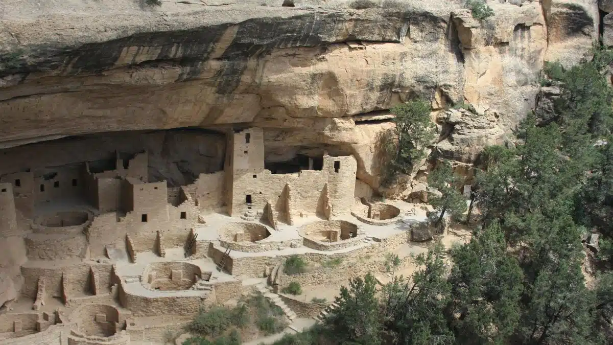
Perched atop mesa tops in southwestern Colorado, Mesa Verde National Park preserves Ancestral Puebloan roads dating to 600-1300 A.D. These weren’t mere trails but formalized routes connecting villages, granaries and kivas, some paved with sandstone slabs. The network supported a population of up to 25,000, with paths descending sheer cliffs via handholds and toeholds.
The 6-mile Petroglyph Point Trail from Spruce Tree House offers access to these ancient road networks, winding past 700-year-old dwellings and along metate-lined walkways. Rangers guide tours, emphasizing how these paths enabled farming communities to thrive in an arid landscape. Spring and fall visits avoid summer heat. Preservation efforts, including trail rerouting, ensure future generations can follow in the footsteps of those who built them.
Hohokam Canal and Road Systems, Arizona
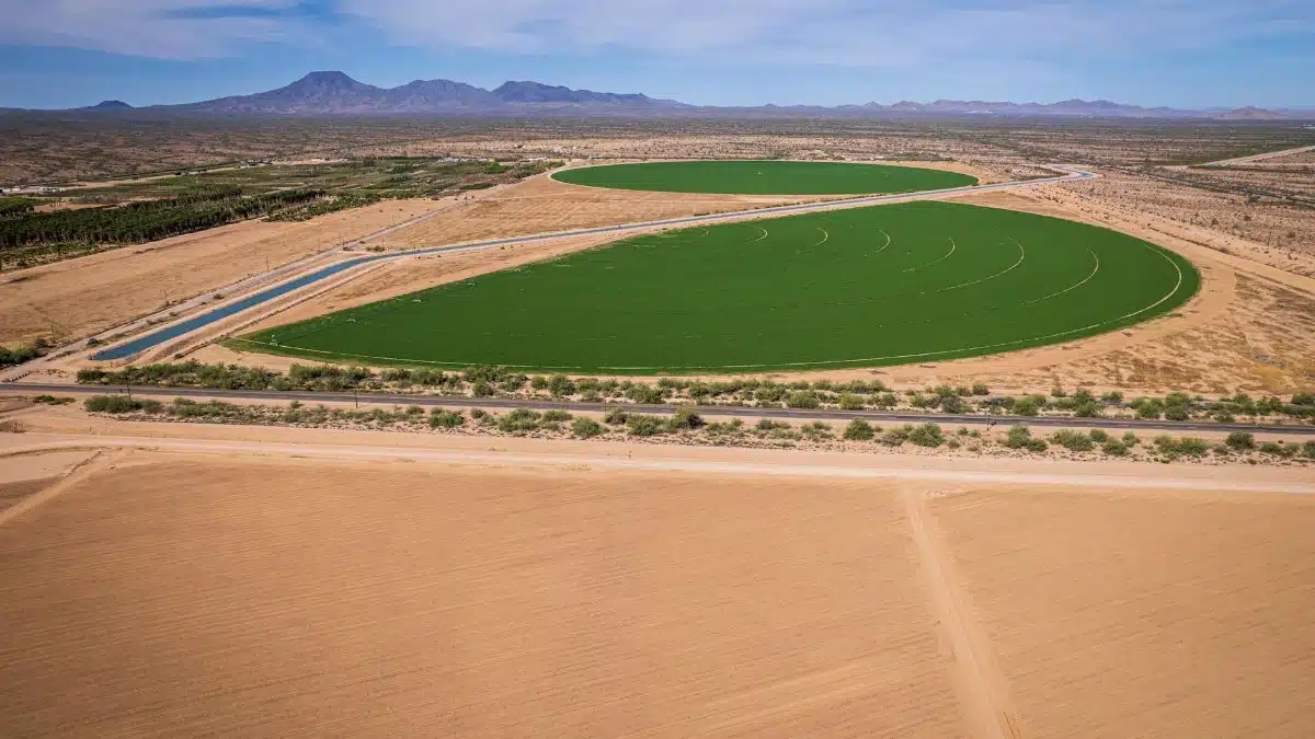
South of Phoenix, the Hohokam culture engineered a 1,000-mile network of canals and accompanying roads from 300-1450 A.D., transforming the Sonoran Desert into farmland. These roads, often paralleling irrigation channels, linked ball courts, platform mounds and villages, facilitating trade across modern-day Arizona.
Park yourself at Pueblo Grande Museum, where a half-mile interpretive trail traces original Hohokam roads amid cottonwood groves. The paths, visible as low berms, once bustled with farmers carrying corn and shells from the Gulf of California. Saguaro National Park also preserves segments hikeable via the 5-mile Ringtail Trail. A Bureau of Reclamation report details their hydraulic precision ( source ), rivaling ancient Mesopotamia.
Sinagua Roads at Tuzigoot, Arizona

Near Clarkdale, Tuzigoot National Monument features Sinagua roads from 1000-1400 A.D., part of a broader network threading the Verde Valley. These earthen avenues, some 10 feet wide, connected hilltop pueblos to riverine fields, with rock alignments guiding the way.
The 0.3-mile self-guided loop at Tuzigoot follows a restored road segment uphill to a 110-room pueblo, offering panoramic views of the network’s remnants. Extend your hike on the nearby 4-mile Verde River Loop for context. Artifacts like pottery shards attest to bustling commerce. Climate change now exposes more of these paths through erosion, a double-edged sword for archaeologists and hikers alike.
Wupatki’s Interconnected Trails, Arizona

Just north of Flagstaff, Wupatki National Monument safeguards a 900-year-old web of Sinagua and Cohonina roads linking seven major pueblos across black lava fields. These paths, averaging 12 feet wide, traversed inhospitable terrain to trade parrots, copper bells and cotton.
The 0.5-mile Wupatki Pueblo Trail directly overlays an ancient road network segment, climbing to a three-story structure with ball court views. Combine it with the 35-mile loop drive for roadside pullouts revealing straightaways vanishing into the distance. Volcanic soils preserved the roads exceptionally well, as noted in National Park Service surveys.
Natchez Trace’s Prehistoric Paths, Mississippi

Winding 444 miles from Natchez, Mississippi, to Nashville, the Natchez Trace Parkway overlays a Native American road network used for millennia by Choctaw, Chickasaw and earlier peoples. Prehistoric sections, trampled deep into the earth, served as buffalo trails and trade routes for salt, flint and shells.
Hike the 2.5-mile Rocky Springs section, where sunken roads flanked by hardwood forest evoke the original paths. Sunken Old Trace trails, some 10 feet below grade, highlight heavy use predating Europeans. The parkway’s interpretive markers detail this layered history, with undesignated spurs for solitude.
Bandelier’s Canyon Rim Roads, New Mexico
In Bandelier National Monument, Ancestral Puebloans from 1150-1550 A.D. built roads along Frijoles Canyon’s rims, connecting cavate dwellings and fields in a 400-square-mile system. These paths featured retaining walls and steps, optimized for foot traffic.
The 1.4-mile Main Loop Trail follows preserved road alignments past 400 alcove sites, ladders optional for deeper exploration. Alcove House Trail adds a half-mile vertical climb on original routes. Wildfires have revealed hidden segments, spurring recent LiDAR mapping by the University of New Mexico ( source ).
Appalachian Indian Trading Paths, North Carolina

In Great Smoky Mountains National Park, sections of the Appalachian Trail trace ancient road networks like the Great Indian Warpath, used by Cherokee and predecessors for 10,000 years. These paths crossed the Smokies, trading deerskins, copper and mica.
Tackle the 7-mile Alum Cave Trail to Mount LeConte, shadowing Cherokee routes with blazed trees and stream crossings. Charles Woods Trail offers quieter access to Bartram’s Path segments. Ethnohistorians link these to 18th-century maps, underscoring their endurance.
These ancient road networks remind us that the land beneath our modern highways pulses with forgotten journeys. Grab a map, pack water and hike them soon, before time claims more. They connect us not just to the past, but to the enduring human drive to link worlds.